
Drone Photography & Aerial Video in Portsmouth & Hampshire
Vantage View provides professional drone photography and aerial video services across Portsmouth, Southampton and the wider Hampshire area. Our aerial imaging is used for property marketing, construction progress monitoring, heritage documentation and commercial projects, helping clients present sites, buildings and landscapes with clarity and impact.
We also provide high-resolution aerial photography in Portsmouth for property marketing, construction projects, heritage documentation and commercial developments.
Recent Aerial Projects Across Portsmouth & Hampshire
Challenger Lighting Floodlighting Showcase at Gosport Borough FC

Filmed during a Gosport Borough FC training session at AEI Stadium, Privett Park, this aerial production was commissioned by Challenger Lighting to demonstrate the effectiveness of their floodlighting installation. Captured using 360° aerial imagery and professionally edited to showcase varied viewpoints, the video illustrates pitch-wide illumination across the club’s 3G artificial turf surface in practical use.

Hinton Manor – Aerial 360° View
Located in the countryside north of Portsmouth, Hinton Manor House is a historic country residence set within the Hampshire landscape near the village of Horndean.
The manor is a Grade II listed property, recognised for its architectural and historic interest. Like many English country houses, it reflects a long tradition of rural estates that developed alongside farmland and local villages, shaping the character of the South Downs region.
Surrounded by open countryside and mature trees, the setting of the manor becomes particularly striking when seen from the air. Aerial perspectives reveal the scale of the property, its grounds, and the wider landscape that frames the estate.
This 360° aerial video, produced for Fine & Country, captures the manor and its surroundings from above. Although presented as a standard video, it was filmed using 360° capture technology, allowing the scene to be recorded in every direction and providing a distinctive perspective of the property and its environment.
Aerial media like this helps estate agents and property owners present homes within their wider landscape, offering potential buyers a clearer sense of location, setting, and atmosphere.

Titchfield Abbey – Aerial 360° View
Rising quietly from the Meon Valley near Fareham, Titchfield Abbey is one of Hampshire’s most fascinating historic ruins. Founded in the early 13th century by Peter des Roches, Bishop of Winchester, the abbey was home to a community of Premonstratensian canons, often known as the “White Canons” because of the colour of their robes.
For more than three centuries, the abbey served both as a religious centre and as part of the wider community, with its canons preaching, studying, and serving nearby parishes. The complex once included a church, cloisters, living quarters, farmland, and fishponds that supported the abbey’s daily life.
The abbey’s story changed dramatically in 1537, when King Henry VIII dissolved monasteries across England. Titchfield Abbey was granted to Thomas Wriothesley, Earl of Southampton, who transformed the monastic buildings into a grand Tudor residence known as Place House.
Over the centuries the house was gradually abandoned and partially demolished, leaving behind the striking ruins we see today. The most distinctive feature is the impressive four-towered gatehouse, created during the Tudor conversion and still dominating the site.
Today, the remains of Titchfield Abbey are preserved as a historic monument and managed by English Heritage. From the ground the scale of the site can be hard to appreciate, but from above the layout of the medieval complex and later Tudor additions become far clearer.
This 360° aerial video offers a unique perspective, allowing you to explore the abbey from the air and look around the historic site in every direction.

Fort Gilkicker Transformed Through 360 Visualisation
(Drone-based construction progress monitoring)
Fort Gilkicker, a historic Victorian fort overlooking Stokes Bay in Gosport, Hampshire, is currently being transformed into a collection of luxury coastal residences. The redevelopment blends historic architecture with contemporary living while preserving the character of this unique coastal landmark.
This 360° aerial video captures the site from above, allowing viewers to explore the fort and its surroundings from every direction. Filmed using 360° drone capture technology, the footage provides a comprehensive view of the structure, the shoreline, and the wider landscape around Stokes Bay and the Solent.
Aerial visualisation like this is particularly valuable for construction progress monitoring and project communication. It enables developers, stakeholders, and potential buyers to clearly understand the scale of the site, the layout of the development, and how the project evolves over time.
360° aerial imagery and video are increasingly used for:
• Construction progress documentation and reporting
• Property development marketing and investor presentations
• Planning, site analysis, and project coordination
• Heritage redevelopment and architectural documentation
By capturing the entire environment in a single recording, 360° aerial technology provides a level of spatial understanding that traditional photography and standard video cannot achieve.
River Meon Inspection – Soberton, Hampshire (February 2026)
Vantage View visited the River Meon near Soberton, Hampshire, in February 2026 to monitor water levels and assess any flood risks. The river was flowing at typical levels for this location, with some elevated flow following recent rainfall, but no significant flooding was observed.
The River Meon is a chalk stream running through rural farmland. While it is not widely used for intensive agricultural irrigation, there are controlled water abstractions downstream for public water supply and occasional agricultural use. These are carefully managed to protect the river’s natural ecosystem.
Vantage View continues to monitor the river, documenting conditions and ensuring early detection of any potential flooding.

360° Aerial Footage

These 360° aerial videos capture the Spinnaker Tower from 120 metres (around 400 ft), while the tower itself rises to 170 metres (approximately 558 ft) above Portsmouth Harbour. The footage provides a striking sense of scale and perspective, showing the tower’s structure and its relationship with the surrounding city of Portsmouth, coastline and developments. One version is fully interactive, while the other is carefully edited to highlight key angles and details.
360° videos allow viewers to explore scenes freely, providing insights and understanding that traditional photography or standard video cannot. They are ideal for construction sites, property listings, architectural projects, or urban developments, enabling clients to:
- Showcase properties, buildings, or sites from every angle
- Present layouts, access, and surroundings clearly
- Reduce site visits while improving decision-making
- Engage audiences with immersive and interactive content
- Create compelling marketing, planning, or project documentation
Using the latest 360° drone technology, released at the end of last year, we help construction companies, builders, estate agents, and developers present sites and properties with maximum impact. Get in touch to bring 360° aerial content to your next project.
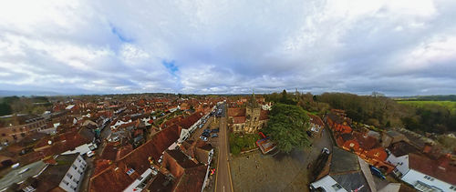
St Mary Magdalene &
St Denys Church

This 360-degree video captures St Mary Magdalene & St Denys Church, a historic landmark at the heart of Midhurst. Dating back over 800 years, the church reflects the town’s long history and character, standing alongside the River Rother within the South Downs National Park.
Midhurst is a traditional West Sussex market town known for its heritage, architecture and surrounding countryside, making it an ideal setting to demonstrate immersive visual storytelling.
Using terrestrial and aerial photography and video, including 360-degree capture, we create immersive content that allows viewers to explore places remotely, understand context and appreciate scale in a way traditional photography and video cannot.
Drone photography and aerial video are widely used for property marketing, construction progress monitoring, heritage documentation and commercial developments across Portsmouth, Southampton and the wider Hampshire area. If you need professional aerial imaging for a project or site, feel free to get in touch to discuss your requirements.

GET IN TOUCH
Inquiries
For any inquiries, questions, or collaborations, feel free to reach out to us here:
Headquarters
Ann's Hill, Gosport, Hampshire, PO12